
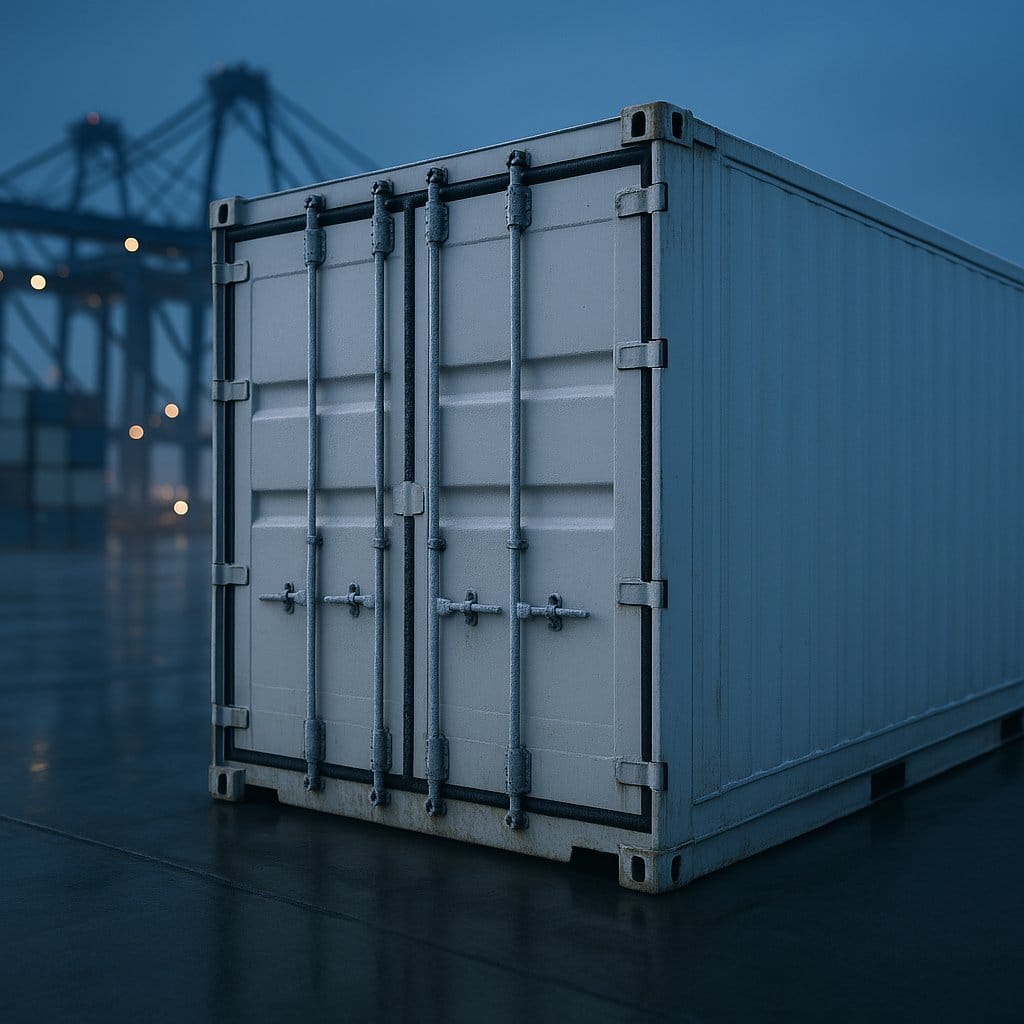
A cargo tracker that reports a clean position at the loading dock and then goes dark for eleven days at sea may not be malfunctioning at all. Two different absences overlap: inside a closed, loaded reefer, GNSS is usually attenuated below usable thresholds; sufficiently far offshore, terrestrial cellular coverage is generally unavailable as well. A properly designed device keeps logging locally through both and uploads the stored record when connectivity returns. A refrigerated container is close to the worst RF environment a cold chain tracker can be asked to work in — and for a device riding entirely inside it, the reasons are structural, not something a marginally better internal antenna fixes.
This article walks through why satellite positioning fails inside a reefer, and then through the fallback chain that well-designed cold chain trackers use: Wi-Fi scanning, cell-ID, and disciplined local logging.
What Happens to a GNSS Signal Inside a Reefer Container?
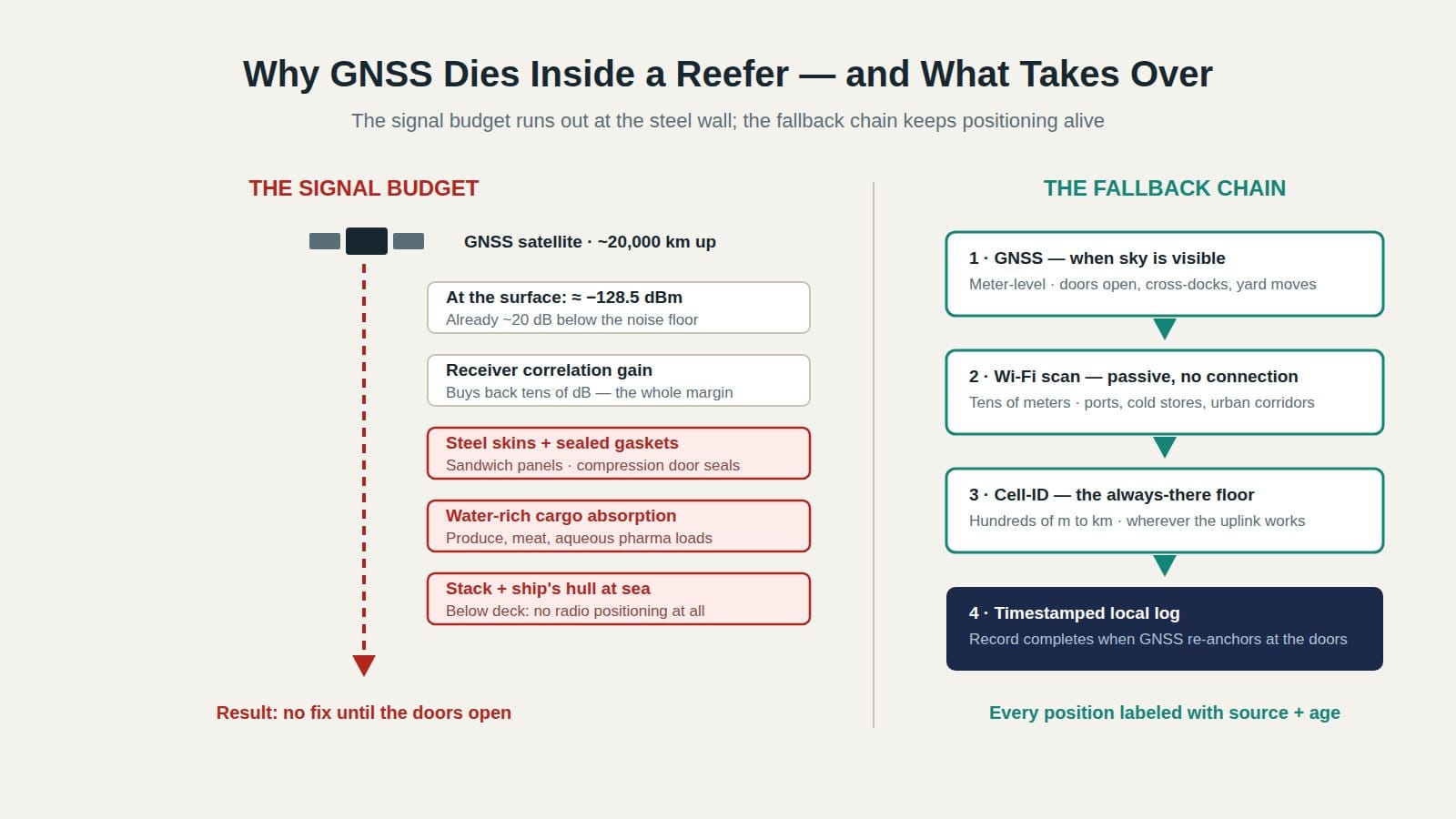
For a device riding inside a closed, loaded reefer, the GNSS signal is usually attenuated below the tracking threshold of even high-sensitivity receivers. The GPS L1 C/A signal reaches a reference antenna under open sky at about −128.5 dBm — already well below the in-band noise — and the receiver recovers it only through correlation gain. Enclosure and cargo loss push the carrier-to-noise ratio under the receiver's threshold, so the device loses lock and typically cannot reacquire until an aperture moment — a door opening, a cross-dock transfer — returns some sky view.
The numbers deserve a moment, because they explain why "put a stronger GPS in it" is not an answer for a fully enclosed device. The GPS interface specification (IS-GPS-200, maintained at GPS.gov) specifies a minimum received power for the L1 C/A signal of −158.5 dBW — that is, −128.5 dBm — at the output of a reference antenna with an unobstructed sky view. That is an extraordinarily quiet signal. Thermal noise integrated across the signal's roughly 2 MHz bandwidth is on the order of −111 dBm at the receiver, which puts the arriving signal some 17–20 dB below the in-band noise before decoding even starts. Receivers only find it because the signal is spread with a known code, and correlating against that code buys back tens of decibels of processing gain.
Modern high-sensitivity receivers stretch that trick to track signals tens of dB weaker still. That margin is what lets a phone get a fix near a window or under foliage. It is a real achievement — and a closed, loaded reefer routinely adds more loss than the margin covers.
Why Is a Reefer Worse Than a Standard Dry Container?
A reefer tends to present more severe and less predictable RF loss than a dry box because it is built to be thermally sealed. Its walls are sandwich panels — conductive skins around insulating foam — its door gaskets are compression seals, and one entire end is occupied by the refrigeration machine. Actual shielding varies by container design, maintenance condition, loading, and where the device sits, but the leakage paths that let a little RF into a dry container are often scarcer and less effective in a reefer.
Four compounding mechanisms:
1. The metal shell
Sheet metal is opaque at 1575.42 MHz — the L1 wavelength is about 19 cm, and the panels themselves suppress direct transmission almost completely, the same principle as a Faraday cage. What remains couples in through seams, vents, drains, and machinery penetrations, and how much gets through depends mainly on aperture geometry, slot length, electrical bonding, maintenance condition, and the device's position rather than simply on panel thickness. A closed steel box does not need to be electromagnetically perfect to defeat a signal that arrived with almost no margin: attenuation through a closed container is not a fixed number, but it is routinely enough to take the strongest satellite from a clean fix to nothing.
2. The seals
RF enters real containers mainly through apertures: door edges, drain holes, ventilation gaps, corrugation seams. A dry box has more of these than intuition suggests, which is why trackers sometimes scrape out a degraded fix near the doors. A reefer's door gaskets, by contrast, are compression seals designed to hold a temperature differential for weeks. Airtightness and RF shielding are different properties — a long, narrow seam can still couple some energy — but a compression-sealed reefer door tends to leave fewer effective leakage paths than a weathered dry-box door.
3. The cargo
Reefer cargo is dense and water-rich — produce, meat, seafood, pharmaceuticals in aqueous solution. Water-rich material introduces substantial dielectric loss, reflection, and scattering at GNSS, cellular, and Wi-Fi frequencies, with the exact effect depending on moisture content, temperature and phase (frozen product behaves differently from chilled), packaging, and how much load the signal must cross. A device buried mid-load is attenuated by the pallets around it even before the walls contribute. This is why placement guidance for in-container devices generally favors the door end and elevation above the load line — validated against the specific container and load plan.
4. The stack
At sea the container is usually one cell in a stack, surrounded by other steel boxes, often below deck inside a steel hull. At that point direct reception of GNSS and public terrestrial cellular networks is generally unavailable — whatever shipboard radio infrastructure exists, a tracker cannot assume access to it — and the design question becomes what the device should do about it, which is a logging problem rather than a positioning problem. A separate deep-dive on satellite-free ocean container tracking covers that store-and-forward architecture in detail.
Why Does the Cellular Link Survive Where GNSS Dies?
Cellular links survive inside containers more often than satellite signals because the link budget is fundamentally different in both directions. A terrestrial base station a few kilometers away delivers vastly more downlink power than a GPS satellite at roughly 20,200 km, base-station receivers are engineered to hear very weak uplinks, and cellular IoT standards were explicitly designed for deep coverage — 3GPP's NB-IoT studies target a maximum coupling loss of about 164 dB, roughly 20 dB beyond the ~144 dB legacy GPRS reference case. That is a link-budget design target achieved partly through narrow bandwidth and repetitions, not a guarantee of coverage inside every container — but it is why the uplink frequently works where GNSS does not.
The asymmetry has a practical consequence that confuses first-time deployments: a cold chain tracker can often report from inside a container while having no position to report. The uplink works; the fix does not. A well-designed device treats these as independent subsystems — it keeps transmitting sensor data and diagnostics on schedule and marks the position field with its source and age, rather than going silent or, worse, repeating a stale coordinate as if it were fresh.
The failure mode also interacts with temperature. A device that spends its power budget retrying GNSS acquisition inside a cold, shielded box is draining a battery whose capacity and pulse-power capability are, for most chemistries, already reduced below zero — a compounding effect covered in the companion piece on why cold kills tracker batteries first. Acquisition retry policy is a battery policy.
Which Positioning Fallbacks Actually Work Inside a Container?
Well-designed cold chain trackers do not treat GNSS as the positioning system. They treat it as the first preference in a chain: GNSS when the sky is visible, Wi-Fi scanning where mapped access points are dense, cell-ID wherever terrestrial coverage and cell-location data exist, and timestamped local logging underneath all three — the only layer that depends on no external radio network at all. Each step trades accuracy for availability.
| Method | How it locates | Typical accuracy | Inside a closed reefer |
|---|---|---|---|
| GNSS | Satellite ranging | Meters | Usually fails — C/N0 driven below tracking threshold |
| Wi-Fi scan | Nearby access point identifiers resolved against a location database | Tens of meters where APs are dense | Sometimes — APs are close and numerous at ports, docks, warehouses |
| Cell-ID | Serving cell (plus neighbor cells and timing where supported) | Hundreds of meters in dense networks to many kilometers in rural cells (indicative) | Often — where terrestrial coverage and cell-location data exist; unavailable beyond the network footprint |
| Logged last fix | Most recent position estimate, with timestamp, source, and uncertainty | An estimate of where the device was — not where it is | Available whenever a valid fix has been recorded |
Wi-Fi scanning: positioning without connecting
Wi-Fi positioning is widely misunderstood as requiring a network connection. It does not. The device scans for access point identifiers and signal levels without ever joining a network — implementations either listen passively for beacon frames or send active probe requests, and neither requires association, a password, or any application data passing through the access point. The scan results go upstream over the device's own cellular link when service is available, or are stored for later upload. A server-side database resolves the list to a position — the technique behind the Wi-Fi positioning systems that mainstream smartphone platforms rely on.
The reason this often works in logistics environments is proximity. An access point fifty meters away in the same terminal building delivers a far stronger signal than any satellite, so a scan can succeed through shielding that GNSS cannot cross — though a fully closed metal box attenuates 2.4 GHz too, and success still depends on leakage paths and on the access points being mapped in a current database. Ports, cross-docks, cold stores, and urban corridors are often dense with access points, which makes Wi-Fi scan a good match for exactly the places cold chain cargo gets handled — and exactly the places disputes happen.
Cell-ID: the widest net on land
Cell-ID positioning uses what the modem already knows: at minimum the serving cell, and — where the modem and network support it — neighbor cells, signal levels, and timing information for a sharper estimate. As indicative figures, errors range from a few hundred meters in dense urban networks to several or tens of kilometers in large rural cells, and the method needs terrestrial coverage plus a cell-location database, so it becomes unavailable once the device moves beyond the terrestrial network footprint. That sounds coarse until the question is framed operationally. "Which terminal is this container in" needs meters. "Did the load leave the port, and is it on the expected corridor" is answered fine by cell-ID — and during a mid-lane excursion alarm, a kilometer-scale position attached to a precise timestamp is enormously more useful than no position at all.
Logging discipline: the layer under the chain

The last layer is not a radio at all. A device that timestamps every sensor reading and every position attempt — including the failures — produces an auditable trip record even when it was blind for days. The doors opening at destination are a positioning opportunity: sky view returns and GNSS can reacquire, and if valid fixes are captured around departure and arrival, they anchor the ends of the dark period while the sensor timeline runs continuous between them. The sensor record is complete even though live tracking was impossible — what the endpoint fixes cannot do is reconstruct the route or locate an event inside the gap, which is exactly why the position source and age must travel with every record.
GNSS inside a reefer is not a hardware deficiency to engineer away. It is a physical boundary to design around — and the design that works is a chain: satellite when the sky is visible, Wi-Fi scan where infrastructure is dense, cell-ID where land coverage reaches, and a disciplined local log underneath all of it.
How Should the Physics Shape Deployment Decisions?
The physics translates into three deployment rules: place the device where aperture moments can reach it, evaluate the fallback chain rather than the GNSS spec line, and tune acquisition retries to the lane instead of leaving factory defaults. Each rule follows directly from the signal budget above.
Taken in order: First, device placement is a positioning decision: door-end and above the load line typically preserves the aperture moments — door openings, cross-dock transfers — where GNSS can snap a fix. Second, spec-sheet review should ask not "does it have GPS" but "what is the fallback chain, and how does the platform label position source and age" — a report that silently mixes fresh GNSS fixes with day-old ones is worse than a gap. Third, acquisition policy should be lane-tuned and event-driven where possible: retries triggered by motion, light, or a change in cellular context catch door openings and transfers, while a fixed few-minute retry schedule inside a sealed steel box mostly buys battery drain on a cell that cold has, for most chemistries, already handicapped.
Frequently Asked Questions
Can any GPS tracker get a satellite fix inside a closed reefer container?
Not reliably, when the device and its antenna ride fully inside. The L1 C/A signal reaches an open-sky antenna at only about −128.5 dBm, and enclosure plus cargo loss usually drives the carrier-to-noise ratio below what high-sensitivity receivers can track. Fixes near container doors on dry boxes come from aperture leakage; a reefer's compression seals tend to leave fewer of those paths open. An externally mounted antenna or a deliberate RF path changes the outcome; an incrementally better internal antenna may help in marginal leakage conditions but is unlikely to make reception reliable.
How does a tracker report a position without GNSS?
Through the fallback chain. The device scans for Wi-Fi access point beacons and sends the identifiers upstream for database resolution, or reports the cellular cells it can hear for a coarser cell-ID estimate. Both ride the normal cellular uplink, which frequently works inside environments where satellite signals cannot reach.
Does Wi-Fi positioning require joining a network?
No. The device scans — passively listening for beacon frames, or sending active probe requests — without ever associating or authenticating. Only the scan results — identifiers and signal levels — travel upstream. This is why the method works at ports and warehouses the device has never visited.
Why does the tracker still send temperature data when it has no position?
Because the cellular link and the GNSS receiver are independent subsystems with different physics. A base station a few kilometers away delivers vastly more signal than a satellite in mid-Earth orbit, and cellular IoT standards were designed for deep coverage. A well-behaved device keeps its sensor reporting cadence and labels the position field with source and age.
Is a position gap during ocean transit a data-quality problem?
Not if the log is disciplined. A timestamped local record with anchored GNSS fixes at departure and arrival, continuous sensor data in between, and honestly-flagged position gaps preserves a complete sensor timeline — the endpoint fixes bound the dark interval even though they cannot reconstruct the route inside it. The gap only becomes a problem when a platform hides it by repeating the last coordinate as if it were current.
Key Takeaways
- GNSS arrives below the in-band noise by design; a closed, loaded reefer usually adds more loss than a receiver's recovery margin can cover. The failure is physics, not product quality.
- Reefers tend to be worse than dry boxes because thermal sealing closes most of the apertures RF leaks through — and water-rich cargo attenuates what little gets in.
- The cellular uplink often survives where GNSS dies, so a tracker can be reachable yet position-blind; the two subsystems should be evaluated separately.
- The working pattern is a fallback chain — GNSS, then passive Wi-Fi scan, then cell-ID — with every position labeled by source and age.
- Timestamped local logging keeps the sensor timeline complete through dark periods: fixes captured around departure and arrival bound the gap, even though they cannot reconstruct the route inside it.